


lac de la BULTIERE VENDÉE

SUPERMAMINOU2004
User
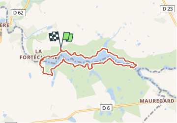

Length
7.7 km

Max alt
76 m

Uphill gradient
83 m
Km-Effort
8.8 km

Min alt
45 m

Downhill gradient
83 m
Boucle
Yes
Creation date :
2024-05-27 13:51:11.738
Updated on :
2024-05-27 16:23:15.355
1h55
Difficulty : Medium

FREE GPS app for hiking
 SityTrail
IGN / Geographical institutes
SityTrail Plus
The world is yours!
About
Trail Walking of 7.7 km to be discovered at Pays de la Loire, Vendée, La Boissière-de-Montaigu. This trail is proposed by SUPERMAMINOU2004.
Positioning
Country:
France
Region :
Pays de la Loire
Department/Province :
Vendée
Municipality :
La Boissière-de-Montaigu
Location:
Unknown
Start:(Dec)
Start:(UTM)
636400 ; 5197965 (30T) N.
Comments